The main natural disasters in Colombia are landslides, earthquakes and volcanic eruptions. Colombia is part of the Pacific Rimg of Fire and the Andean Volcanic belt. Because of its location, Colombia is more prone to Earthquakes and volcanic eruptions. Colombia is known to be one of the most disaster primed countries in the world. At least 85 percent of the population are exposed to two or more diasters. If I was in charge of Colombia I would try to first prevent earthquakes, or better prevent them.My country is at a very high risk of earthquakes because of its location. Tsunamis are important but not as important as earthquakes because only western part of the country is at risk. The country at whole is at risk of earthquakes because there are two plates that run through it. I think with earthquakes there is more disaster with the country as a whole than with tsunamis. I would have everyone rebuild their homes to make them secure in case of an earthquake so that no one would be greatly affected and they would still have their homes after the disaster. everyone’s home would be safe and make them according to the earthquake regulations. I would also make sure everyone took classes to prepare the citizens in case there was a catastrophic event. I would make shelters and have enough food and toiletries for everyone. I believe if I was in charge of Columbia there wouldn’t be anyone suffering if there was a disaster. If I had to build a house in colombia I would build it in an area inland but somewhere not too populated. That way supplies wouldn’t run out as quick and I wouldn’t have to worry about so much traffic everywhere of people trying to get help.
https://www.worldnomads.com/travel-safety/south-america/colombia/natural-disasters-in-colombia
https://www.preparecenter.org/countries/colombia
Monday, May 21, 2018
Friday, April 27, 2018
Coastal Hazards
Coastal erosion became a serious problem along the Caribbean coast of Colombia.
48.3% of the coast is experiencing erosion.
Because of the tectonic setting, the Pacific coast of Colombia is prone to many geological hazards.
Erosión al trends are 700 km long. “Low barrier island’s shorelines of the Pacific littoral and land losses are enhanced by factors as 30 cm regional sea level rises associated to the occurrence of El Niño.”
Marine erosion is threatening villages and worsening the socioeconomic conditions of most of the people.
Because of the will power to stay near the sea, the inhabitants has consisted of repetitive inshore and along shore directed relocations of villages. The people living here face great danger so they are told to move further inland instead of completely leaving and abandoning their area.
This all has caused repetitive relocation and economical loss.
https://www.sciencedirect.com/science/article/pii/S0964569115001775
Wednesday, April 4, 2018
Extreme Weather

In 2016 Hurricane Matthew killed one person and affected more than 18,000 families. The person who died was an 67 year old man who was swept away by a flash flood in an area where it had not rained in 4 years. The primary damage was done to homes and infrastructures as regions flooded and rivers overflowed the banks. Hurricane Matthew reached category 5. It was the strongest Atlantic hurricane to hit the coast of Colombia since Hurricane Felix in 2007.
https://www.washingtonpost.com/national/hurricane-matthew-drenches-coastal-colombia/2016/10/01/e34fa784-8803-11e6-ac72-a29979381495_story.html?utm_term=.a916ee667725
Friday, February 23, 2018
Volcanoes
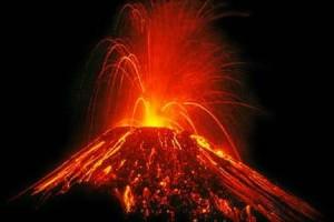
Colombia has 15 volcanoes that are considered active. They are related to the subduction zone. They lie at the junction of three tectonic plates, the Nazca, Carribbean, and South American plate.

In November 1985, the Nevado del Ruiz eruption was one in a series of prolonged volcanic and seismic events that led to the knowing that magma was moving near the surface of the volcano.
After the Armero disaster, Colombia established a plan for warning and evacuation of threatened areas in case of another eruption. The planning included time phased response, rescue and medical aid, means of transportation, evacuation routes, alert procedures in government, formation and communication of public warnings and the review and revision of plans.
A public education campaign went underway to educate citizens that live in towns that are at risk. students were educated on volcanoes and what to do if one erupted. The civil defense and the Red Cross handed out flyers to the public about the volcanic hazard, informing the people to evacuate when they heard the siren to alert them about a volcanic eruption.
Hazard maps made on posters were made to prepare the people at risk what to do when they heard the alarm.

https://www.volcanodiscovery.com/colombia.html
https://www.nap.edu/read/1784/chapter/10#82
Tuesday, February 6, 2018
Earthquakes

Earthquakes
Colombia is an earthquake "hot spot." It is prone to mudslides because of its mountainous terrain. These mountains are caused by the movement of the tectonic plates.

After the big earthquake in Mexico, Colombia discussed their concerns about Medellin, the country's second largest city. The Nazca Plate runs through the western part of Colombia. Ana Beatriz Acevedo who is a researcher at EAFIT University, categorizes Medellin at medium risk for an earthquake of at least 6 on the Richter scale within the next decade because of the location being so close to the ring of fire. Many houses in the country are not built over solid rock which makes them prone to earthquakes. Almost 90% of the population lives in medium to high risk zones. Colombia has seismic regulations for construction. The houses that are at risk were built before the regulations.

https://thebogotapost.com/2017/05/20/mocoa-preventing-future-disaster/
https://www.colombiafocus.com/medellin-is-not-prepared-for-an-earthquake-researchers-say
https://earthquaketrack.com/p/colombia/recent
Tuesday, January 30, 2018
Tectonic Plates
Colombia is about 110 miles from the Coco’s plate. To the East is the Nazca Plate. It sits right on the South American plate and the Caribbean Plate.
Subduction at these boundaries has pushed up rock making mountains that exist on the coast of Colombia.
This country is part of the Ring of Fire, because of the collision of the South American Plate and the Nazca plate, Colmbia is at a high risk for earthquakes and volcanic eruptions. It is also at risk of flooding and tsunamis.


http://www.basicplanet.com/pacific-ring-fire/
http://www.nationsencyclopedia.com/geography/Afghanistan-to-Comoros/Colombia.html
https://www.livescience.com/37384-colombia-complex-tectonics-earthquakes.html
Subduction at these boundaries has pushed up rock making mountains that exist on the coast of Colombia.
This country is part of the Ring of Fire, because of the collision of the South American Plate and the Nazca plate, Colmbia is at a high risk for earthquakes and volcanic eruptions. It is also at risk of flooding and tsunamis.
http://www.basicplanet.com/pacific-ring-fire/
http://www.nationsencyclopedia.com/geography/Afghanistan-to-Comoros/Colombia.html
https://www.livescience.com/37384-colombia-complex-tectonics-earthquakes.html
Friday, January 26, 2018
Difference between hazards, disasters & catastrophes
When people talk about disasters, catastrophes and hazards, they think about them as all meaning the same thing.
- A hazard is a potential danger that poses a threat to people or property that exists or is caused by nature. Generally it isn’t made or caused by humans.
- A disaster is a hazardous event that occurs over a limited time span within a defined area.
- A catastrophe is a massive disaster that requires significant expenditure of money and a long time for recovery.
Subscribe to:
Comments (Atom)
-
Earthquakes Colombia is an earthquake "hot spot." It is prone to mudslides because of its mountainous terrain. These mountai...
-
When people talk about disasters, catastrophes and hazards, they think about them as all meaning the same thing. A hazard is a potential ...
